Site Description Managed (grazed) alpine grassland at 1900–2500 m asl, mainly on calcareous bedrock. The area and the adjacent facilities are part of the ETH Research Station. Eddy covariance flux measurements were carried out in campaign mode during summer in 2006 to 2014 (tower coordinates: 46°34’59.2″N and 9°47’26.3″E at 1978 m asl). Since 2014, measurements are running continuously.
Location
Altitude : 1978 m a.s.l.Site name : Alp Weissenstein, Kt. Graubünden, SwitzerlandParcel name : Hirschwiese 3C (location of eddy covariance station)Land use : Grazing 1-2 times per year, summer-grazed pastureCoordinates : 46°34’59.2″N 9°47’26.3″E (46.583102, 9.790624) (Google Maps )Location description : – FLUXNET ID : CH-Aws
Climate All numbers shown are for the time period 2015-2021 .
Air temperature
Average air temperature : 4.0°CWarmest year : 2020 (4.5°C)Coolest year : 2021 (3.3°C)Highest measured air temperature : 26.9°C (26 Jun 2019, half-hourly average between 14:30 and 15:00)Lowest measured air temperature : -19.9°C (27 Feb 2018, half-hourly average between 18:30 and 19:00)
Numbers updated 8 Feb 2022
Nearby meteo stations
Vegetation
Land cover (IGBP land classification): coming soon Community : Deschampsio cespitosae-Poetum alpinae (at research site), Trifolio thalii-Festucetum violoceae (slope above research site)Height : 10-40cmLeaf area index (LAI) : max. 4 m2 m-2
Soil
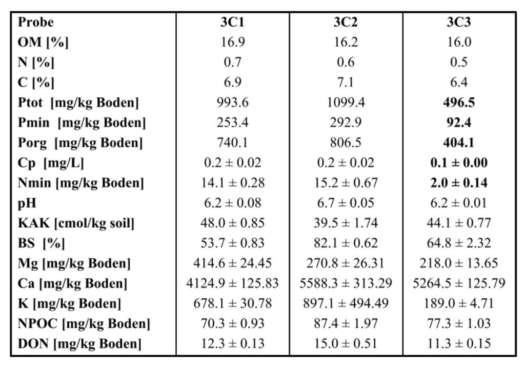
Geology : Underlying material built by moraines from the Val Bever glacier and by limestone debris from the steep valley slopesthat overlie the glacial formation.Soil type : slightly humous to humous sandy loam (Hiller et al., 2008 )Soil texture : coming soon Soil analysis :
from: M. Schärer (2003) Kurzbericht der Fallstudie Alp Weissenstein, Nährstoffanalysen in Alpweiden Sommer 2002, ETH Zürich, unpublished
Data Current Flux Products
CH-AWS
GRA
FLUXNET
FLUXNET2015 (v2024)
19 Aug 2024
2006
2023
NEE,ET,LE,H
Download 11676/YTVB92-LRk51MUP_JShi7f4u
Notes
CH-AWS
GRA
PI
FP2022
08 Feb 2022
2015
2021
NEE,ET,LE
Notes
Available Level-1 Fluxes
128
CH-AWS 2020
HS50
IRGA72
CO2
H2O
FF-202201
FF-202101
18 Apr 2021
UPDATE
Show
5
CH-AWS 2006
R2
IRGA75
CO2
H2O
FF-202002
FF-202002
15 Oct 2020
NEW
Show
6
CH-AWS 2007
R2
IRGA75
CO2
H2O
FF-202002
FF-202002
15 Oct 2020
NEW
Show
7
CH-AWS 2008
R2
IRGA75
CO2
H2O
FF-202002
FF-202002
15 Oct 2020
NEW
Show
8
CH-AWS 2009
R2
IRGA75
CO2
H2O
FF-202002
FF-202002
15 Oct 2020
NEW
Show
9
CH-AWS 2010
R2
IRGA75
CO2
H2O
FF-202002
FF-202002
15 Oct 2020
UPDATE
Show
10
CH-AWS 2011
R2
IRGA75
CO2
H2O
FF-202002
FF-202002
15 Oct 2020
UPDATE
Show
11
CH-AWS 2013
R2
IRGA75
CO2
H2O
FF-202002
FF-202002
15 Oct 2020
NEW
Show
12
CH-AWS 2014
R2
IRGA75
CO2
H2O
FF-202002
FF-202002
15 Oct 2020
NEW
Show
13
CH-AWS 2015
R2
IRGA75
CO2
H2O
FF-202201
FF-202002
15 Oct 2020
NEW
Show
14
CH-AWS 2016
HS50
IRGA72
CO2
H2O
FF-202201
FF-202002
15 Oct 2020
UPDATE
Show
15
CH-AWS 2018
HS50
IRGA72
CO2
H2O
FF-202201
FF-202002
15 Oct 2020
UPDATE
Show
16
CH-AWS 2017
HS50
IRGA72
CO2
H2O
FF-202201
FF-202002
15 Oct 2020
UPDATE
Show
18
CH-AWS 2019
HS50
IRGA72
CO2
H2O
FF-202201
FF-202002
15 Oct 2020
NEW
Show
137
CH-AWS 2021
HS50
IRGA72
CO2
H2O
FF-202201
FF-202201
04 Oct 2023
NEW
Show
138
CH-AWS 2022
HS50
IRGA72
CO2
H2O
FF-202305
FF-202305
04 Oct 2023
NEW
Show
139
CH-AWS 2023
HS50
IRGA72
CO2
H2O
FF-202402
FF-202402
06 Mar 2024
NEW
Show
140
CH-AWS 2024
HS50
IRGA72
CO2
H2O
FF-202502
FF-202502
10 Feb 2025
NEW
Eddy covariance raw data files Dataflow
Photos You are here: CH-AWS, Alp Weissenstein
Site map, last update 9 Sep 2022. - MAP, YEAR-2022, MONTH-09, SITE-CH-AWS
Site location before the site was installed (2005). - SITE-CH-AWS, YEAR-2005, MONTH-08
SITE-CH-AWS, YEAR-2006, MONTH-06
SITE-CH-AWS, YEAR-2006, MONTH-06
Photo: Valentin Klaus (ETH) - SITE-CH-AWS, YEAR-2019, MONTH-06
Photo: Valentin Klaus (ETH) - SITE-CH-AWS, YEAR-2019, MONTH-06
Photo: Valentin Klaus (ETH) - SITE-CH-AWS, YEAR-2019, MONTH-06
Photo: Matti Barthel (ETH) - SITE-CH-AWS, YEAR-2019, MONTH-06
Photo: Matti Barthel (ETH) - SITE-CH-AWS, YEAR-2019, MONTH-06
Photo: Matti Barthel (ETH) - SITE-CH-AWS, YEAR-2019, MONTH-06
Distances between eddy covariance tower, rain collector and meteo mast. Created 28 Mar 2019. - SITE-CH-AWS, MAP, YEAR-2019
SITE-CH-AWS, MONTH-01, YEAR-2018
SITE-CH-AWS, MONTH-01, YEAR-2018
SITE-CH-AWS, MONTH-01, YEAR-2018
SITE-CH-AWS, MONTH-11, YEAR-2014
SITE-CH-AWS, MONTH-11, YEAR-2014
SITE-CH-AWS, MONTH-11, YEAR-2017
SITE-CH-AWS, MONTH-11, YEAR-2017
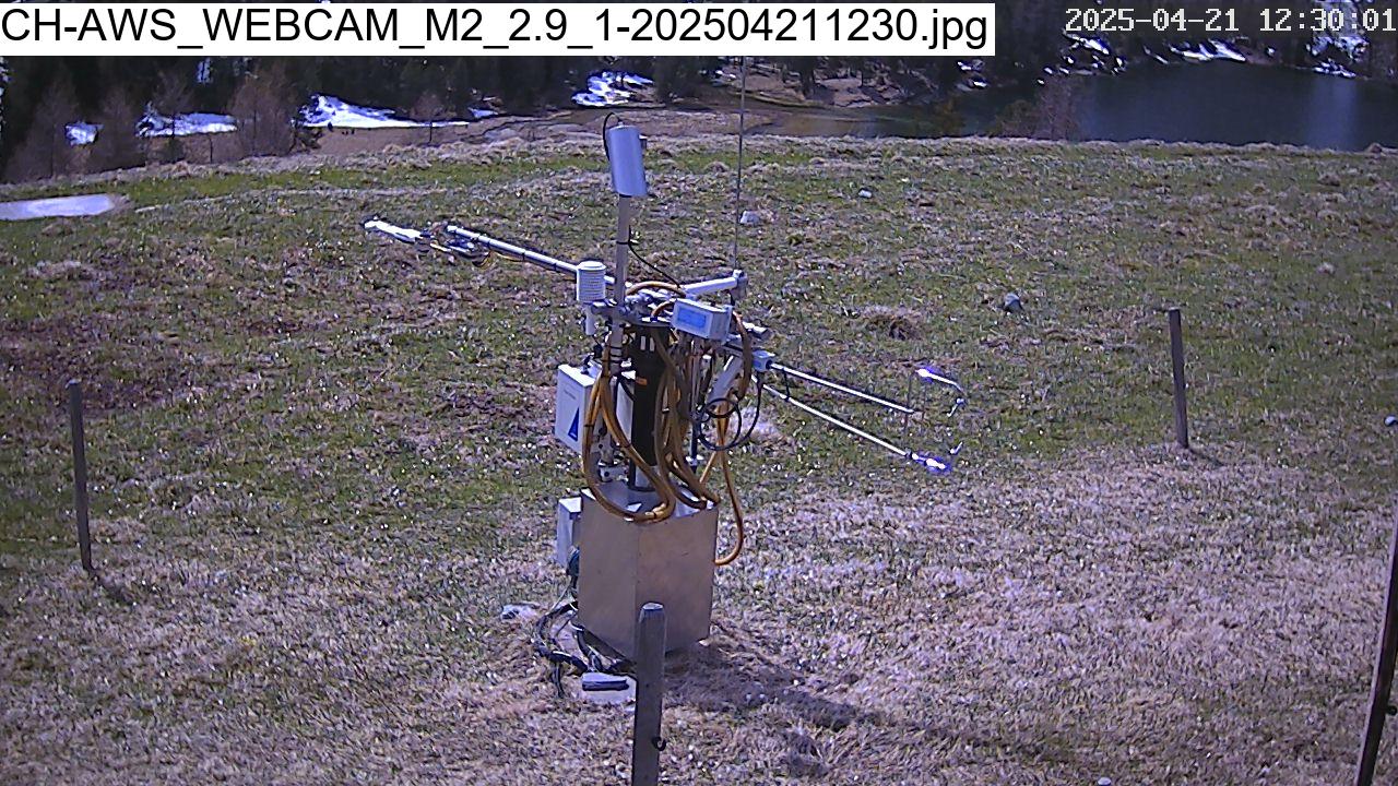
Webcam
Most recent image from main tower
Fieldbook
News
More Info Last Updated on 12 Feb 2025 19:03


